Making them fly was the easy part. Making them useful was the next challenge. And now unmanned aerial vehicles (UAVs) are being put to the test to determine where they are the most applicable to the oil and gas industry. Companies and university researchers developing these “flying computers” believe that their sector is ready to rapidly expand, because of recent technological advancements and legislation that will open up the unmanned skies in the industry’s largest potential market by 2015: the United States.
UAVs are already being used by some oil and gas companies to inspect flare stacks and track migrating wildlife and ice floes in the Arctic. In the near future, UAVs will be used as important tools to respond to oil spills and pipeline monitoring, and in offshore installation and decommissioning operations.
A few years ago, the militaries of the world held a virtual monopoly on the application of UAV technology, and UAVs available to the private sector were little more than eyes in the sky with limited functionality. Today, commercial UAVs are the benefactors of miniaturized electronics, partly thanks to the smartphone industry and advanced software programs specifically designed to make sense of the different types of data that can be gathered while flying. Equipped with lasers, high-definition cameras, thermal imaging systems that can “see” at night, and an array of other sensors, advocates of UAVs claim they are not simply cheaper alternatives to fixed-wing aircraft and helicopters, but in many ways are more capable and, without question, safer to operate.
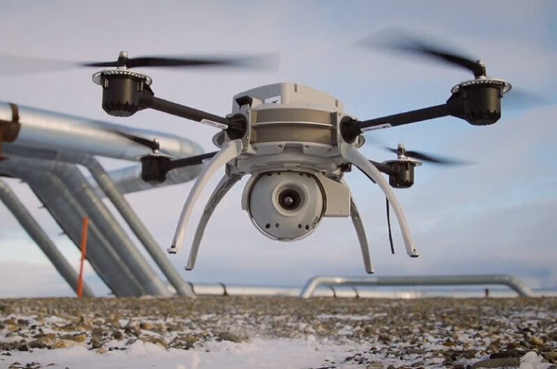
Last fall, BP completed an experimental flight in Prudhoe Bay, Alaska, using a quadrotor UAV developed by Canadian-based Aeryon Labs. Quadrotor UAVs, also called quadcopters, use four rotors to lift and move the aircraft and are known for their maneuverability. At the time, US authorities were only issuing flight certificates to determine the airworthiness of UAVs without allowing commercial operations. BP completed the test run to determine how Aeryon’s UAV could inspect oilfield equipment and pipelines to assess maintenance needs.
The Aeryon Scout, a 3-lb backpack-sized UAV capable of carrying out 20-min reconnaissance flights, has been used on every continent, except Antarctica, and was used by Libyan rebels in support of their march on Tripoli in 2011. Aeryon said it makes flying UAVs as easy as possible by integrating airborne and satellite maps into the navigation system, which is installed on a touch-screen tablet. “We’ve built a system that flies itself and the operator just tells it where to go,” Dave Kroetsch, cofounder and president of Aeryon, said. “Anyone can pilot it and it is very easy to use. Simply touch and guide.”
An upgrade to the Scout, the SkyRanger, is twice as capable with a flight time of up to 50 min and comes equipped with a high-definition camera instead of a standard-definition camera. Electronics manufacturers have been able to shrink the size of critical components, including thermal sensors and imaging systems, thus giving UAV companies more flexibility. “Things are getting smaller, which is giving us the ability to fly longer,” Kroetsch said, noting that, “while there is a lot of interesting experimentation going on, there are not big rollouts in (the oil and gas) industry quite yet.”
Aerial Geologic Modeling
In July, researchers from the Virtual Outcrop Geology (VOG) group at the Centre for Integrated Petroleum Research (CIPR) in Norway used an experimental UAV to analyze the geometry of exposed sedimentary rock formations in Spain. The group’s focus is the study of geologic outcrops to address reservoir-related challenges. Geologists have long used outcrops as accessible and in-situ means of studying rock formations that have characteristics similar to a subsurface reservoir.
The research team piloted a small-sized UAV equipped with a digital camera just a few meters from the outcrops, taking thousands of images. After taking several short 10-min flights to cover as many angles as possible, the image data was used to generate a 3D model of each outcrop (Fig. 1).
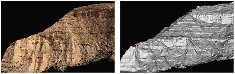
“We’re looking at geological features that might be the same as what is inside the reservoirs,” said Simon Buckley, a senior CIPR researcher and project leader of the VOG group in Bergen, Norway. “This technology helps us to understand the configuration of different kinds of rock, the geological features within the rock, and how they would affect oil production in the reservoir.”
The VOG group has been using 3D laser scanning technology for nearly a decade to scan surfaces within a centimeter of accuracy. Helicopters outfitted with the same type of laser have been used before, but would have to fly above the outcrops at dangerously low altitudes to achieve the same resolution as the UAV can with the digital cameras. In addition, UAVs cost less than 3D laser technology and can obtain data in significantly less time.
Outcrop data may help geologists and petroleum engineers fill in small gaps in subsurface geologic data by allowing the detailed study of features too small to be detected by seismic technology. “Even if you have a layer (of rock) 1 cm thick, it may have a significant effect on how fluid flows through it,” Buckley said. Using enhanced-imaging UAV technology, geologists in the future may hold the potential to identify other issues and anomalies, “that you don’t see in the seismic data,” he said.
The project is part of a study being funded by a consortium of 17 companies based in Norway, including oil and gas companies, to develop a database of outcrops that can be studied by students and geologists. With this type of data, geologists have the ability to build models to simulate an oil and gas reservoir for fluid flow analysis.
Making Inspections Safer
A main driver for the widespread use of UAVs is the health and safety benefits that they offer. Some in the burgeoning UAV industry liken their introduction to the oil and gas industry to the emergence of another robotic technology: remotely operated vehicles (ROVs). “Initially, ROVs were seen as a bit gimmicky with limited use,” Chris Fleming, cofounder and operations director of Cyberhawk, said, “but now they’re used routinely all over the world.”
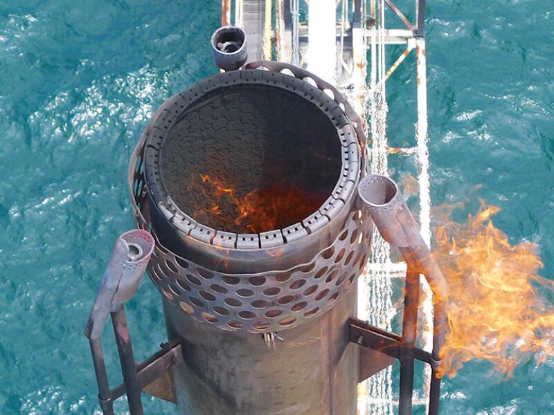
The core business of Cyberhawk, a UAV inspection and surveying company based in the United Kingdom, is live flare inspection. It uses pairs of trained pilots and qualified inspectors to fly and interpret the images captured by its rotor-propelled UAVs, each weighing less than 5 lb (2 kg). The company founders were working as oil and gas inspection engineers when they realized the potential of UAVs.
“We had the idea that we could use flying robots for inspection because, in some cases, we were asking people to be put in dangerous environments to basically tell us if something was there, or if something was in reasonable condition,” Fleming said. “In the past, you would have to shut down the flare to carry out the inspection, or in some cases in the United States, you have people in protective suits going up to inspect and carry out maintenance on a live flare at the risk of being burned.”
After establishing Cyberhawk in 2008, the founders spent the first 2 years proving to themselves that the technology worked before approaching their old bosses in the oil and gas industry. It took the company another 2 years to build a track record of more than 150 successful onshore UAV operations for major oil and gas companies in the Middle East, southeast Asia, and Europe.
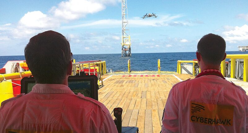
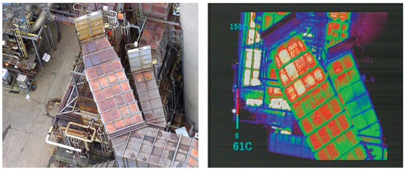
Last year, the company was awarded its first offshore contract to inspect a derrick on a drilling rig. Because the operation was completed without having to stop drilling operations, which is the normal procedure for a manned inspection, Cyberhawk says it saved the operator more than GBP 4.6 million (USD 7.2 million). In another offshore project, the company was called to assist Shell with decommissioning a North Sea platform. In previous campaigns, Shell had tried erecting scaffolding beneath the platforms to inspect the integrity of the under deck, but frequent storms sent half-completed scaffold structures to the seafloor, causing significant setbacks. “We were able to do the under-deck survey in 5 days versus a 2-month scaffolding campaign,” Fleming said. “Using our inspection data, they were comfortable enough to say that the under deck was in good enough condition to hold together and the platform could be lifted off in one go.”
Fleming expects to see more offshore companies use UAVs during key offshore events such as topside installations. Other developments, he predicts, will make it possible to fly tiny micro-UAVs capable of autonomous inspections inside bulk storage tanks to generate 3D images that would reveal critical defects if present—a sometimes hazardous task for humans, because of chemical fumes that may be present.
Tight Restrictions in the US
UAV experts say a broad ban in the US on the commercial use of UAVs is holding back market growth. Countries such as Norway and Canada have been more relaxed in allowing routine commercial UAV flights, and still other countries have no restrictions on UAVs. The US government, meanwhile, has set a deadline of September 2015 for itself to establish the regulations that will govern the use of UAVs in its domestic airspace. When the rules are in place and the ban is lifted, the leading UAV industry group, the Association for Unmanned Vehicle Systems International, projects that the US market alone will generate more than USD 82 billion in revenue within a decade.
While those rules are being worked on, commercial licenses for UAVs are being issued on a case-by-case basis in the US for flights over Alaska, where oil companies are studying how to use the technology to facilitate safe exploration of the Arctic Ocean. ConocoPhillips, which was granted one of two commercial licenses in July to operate UAVs over Alaska, said that it is working with US regulatory bodies to evaluate the safety of the technology and is in the final stages of determining how the company will use UAVs in its operations.
The only other company to receive approval for its commercial operations in Alaska is Aerovironment, the largest supplier of UAVs to the US military. The type of UAVs that the company makes are smaller and lighter weight and make up 85% of the US military’s UAV inventory, but they only account for 3% of total defense dollars spent on the technology. Companies such as Aerovironment are eager to show regulators and the oil and gas industry the reliability and value of this new technology. “This is a very important step along that path and it is opening up a region that can be quite difficult to operate an aircraft in and is much less populated than other areas,” Steve Gitlin, an Aerovironment spokesman, said.
The company will begin flying its UAV, known as a Puma AE, over the coast of the Beaufort Sea in the Arctic Circle this year in support of emergency response crews for oil spill monitoring and wildlife observation. The UAVs provide the ability to maintain constant surveillance on ice floes that may put offshore facilities and vessels at risk of collision if not spotted early and can detect the presence of whales. In case of an oil spill in the Arctic, UAVs will be among the first systems deployed to determine the extent and direction of the spill.
The Puma AE has a wingspan of 8 ft and is capable of staying airborne for more than 9 hr using new battery technology and flexible solar panels that wrap around the top of the wings. Weighing only 13 lb, the Puma AE can be assembled in minutes by snapping the pieces of the aircraft together and is waterproof, allowing it to touchdown safely on land or sea. “Unlike larger systems that require runways or machinery to launch and land, or large teams of people, our systems are portable,” said Gitlin. “You just toss it into the air.”
Depending on how each aircraft is equipped, Aerovironment says a package of three UAVs, including spare parts and a ground communication system, costs between USD 100,000 and USD 200,000. This compares with traditional fixed-wing aircraft and helicopters that can cost up to USD 3,000/hr of flight time.
Software Integration
This summer, Portugal’s military carried out a mission to prove how UAVs could quickly locate oil slicks and spills. It requested the help of Raja Sengupta, a professor and leading researcher in wireless communications and inertial navigation for UAVs at the University of California at Berkeley.
To simulate the oil spill, the Portuguese navy dropped 100 kg (220 lb) of popcorn in the Atlantic Ocean. “Then we had a UAV take off from a runway and we handed off control from one station to another station, because it flew about 40 to 50 km away,” Sengupta said. “And then it went under the control of a ship that was near the popcorn. The UAV searched the area, found the popcorn, imaged the popcorn, and told the ship where the popcorn was.”
The naval vessel then sailed to the exact location of the popcorn and placed drifting devices in the water to track the popcorn and take water samples. The drifters beamed the data they were collecting up to the UAV, which then brought the data back to the air force base where it left from. Flying in a scanning pattern over 100 km2 (62 sq miles) of open water, the UAV located the popcorn in less than 90 min and the operation from takeoff to landing lasted less than 3 hr. The operation showed how UAVs need to be integrated with different types of communications software onboard vessels, ground stations, and satellites.
“All of these different information systems have to bridge with each other,” Sengupta said. To that end, he and other researchers are working to develop the software tools that will enable UAVs to be controlled by multiple types of computer platforms. Additionally, artificial intelligence will help make UAVs safer to operate. Avoidance systems must be fully developed to ensure that UAVs steer clear of other aircraft to prevent midair collisions.
“We’re certainly not going to make helicopter and airplane pilots responsible for avoiding UAVs,” Sengupta said. “The UAVs will have to avoid them.”
Icing in the Arctic
Other technical hurdles for the UAV industry remain. Among them is the phenomenon of icing that occurs in areas such as the Arctic, even if temperatures are a few degrees above freezing. When moisture-saturated air, or fog, evaporates off the wings of a UAV, it cools just enough to leave a small amount of ice on the aircraft’s surface.
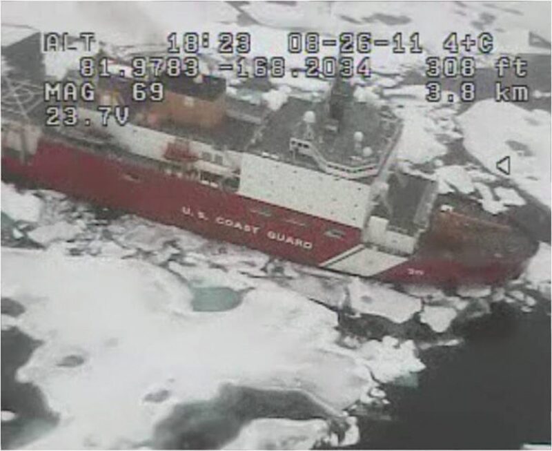
It does not take very long to ice up a small unmanned aircraft so that it is no longer responsive to controls,” said Philip McGillivary, science liaison for the US Coast Guard Pacific Area. “That’s an issue that hasn’t been resolved by anyone. So we’re working to get that solved,” he said. McGillivary is advising in UAV studies at the Norwegian University of Science and Technology, Norway’s main engineering university, in collaboration with Statoil, and is helping draft UAV flight protocols for the National Science Foundation.
The conventional de-icing chemicals used on manned aircraft do not apply to UAVs because of their small size. McGillivary says that new technologies such as carbon nanotube paint could be used to eliminate icing, because a small electrical charge flows through the paint to keep the wings warm. Other solutions for camera and sensor housings, which usually need to be transparent, could include using glass with nano-grooves too small to notice with the naked eye, but which are just the right size to prevent droplets from forming and turning into ice.
McGillivary, who lost a fellow researcher and friend after his plane crashed in the Arctic, understands the potential that UAVs hold as a lifesaving and enabling technology. “In the Arctic, manned flight is quite expensive and at times, quite dangerous,” he said, pointing out that the nearest US Coast Guard rescue station is almost 1,000 miles away from where oil companies have said they plan to explore for oil and gas in the Arctic. “Of course, unmanned aircraft are not as risky because there’s no human in there. If you lose one, you lose a piece of gear, not several people’s lives,” he said.